Cotter of Anngrove & Rockforest
Cotter Family Vault
Its History
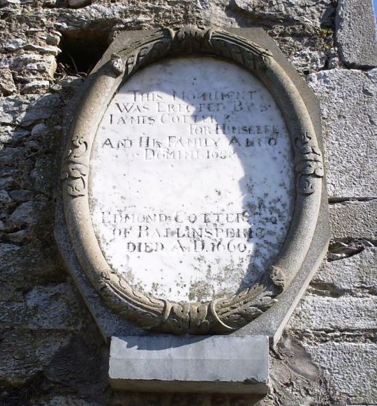
Like so many things associated with the ancient ruinous Augustinian Canon Abbey, the precise location of the Cotter family vault has long been shrouded in mystery. It began with Edmond Cotter whose death took place in 1660 at Ballinsperig (Anngrove), Carrigtwohill, memorialised by an Italian marble plaque which once surmounted the family vault within the Abbey grounds; lying, it is believed, somewhere near or beneath the modern extension abutting the former St David’s Church which underwent substantial renovation in 1835. Today it is mounted high on the former Abbey Belltower with an inscription which reads:
"This monument was erected by Sir James Cotter for himself and his family Anno Domini 1688.
Edmond Cotter of Ballinsperig died A. D. 1660"
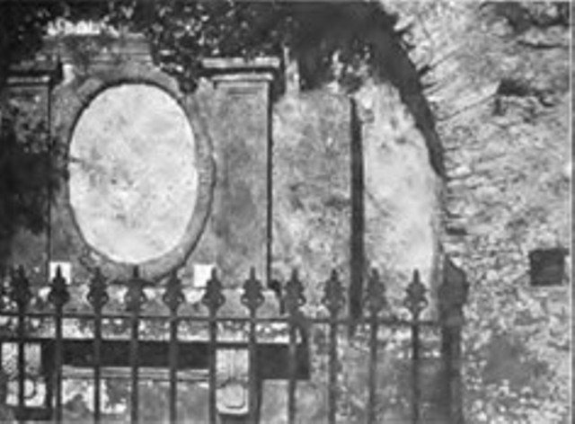
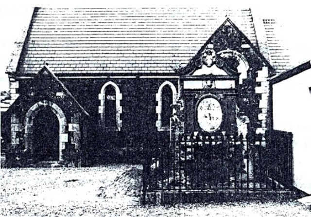
Almost immediately since the formation of Carrigtwohill & District Historical Society in 2010, the precise location of the Cotter family vault has been hotly debated by our members. More particularly since finding three very different published images of it. Many historical accounts have it located in the Nave of the original St David’s Church sited on the ruins at the western end of the Abbey.
The earliest image so far found was in an article by Mr G. Thompson published by JCHAS in 1908, soon after his visit to the village that year. His photograph clearly shows the memorial and vault within an arch similar to those found on the ancient abbey, surrounded by a wrought iron railing. Of his visit he wrote:
‘… was in good preservation, in spite of its age and exposure to the weather, It appears to have been first set up within what was probably the pre-Reformation church of Carrigtwohill, whose tower still remains, in one of the bays at its north side. On part of the site of this old church a more modern Protestant church was erected, leaving portions of the old church east and west of it to go entirely to decay, so that the Cotter monument has no longer any overhead protection. This second church has been replaced by a still smaller one, built close to it on the north in 1905. But the ancient tower happily remains, to the left of which is the Cotter monument...’
Another rather grainy image appeared in a private publication by a local family historian, but contained many additional topics of local interests.
|
|
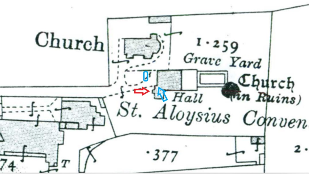
It is generally accepted by our committee that the family vault was likely situated in the link between original St David’s Church and the belfry, highlighted by the red and blue arrows on below map kindly provided by PSMG Convent Archives. Committee member, Michael Cummins, an Architect, suggests that wall (red arrow) must have been the original side wall of the church, with the Nave extended out to the western face of the tower. The roof of that part of the nave later collapsed exposing the arch to the open air as described by Mr Thompson in 1908.
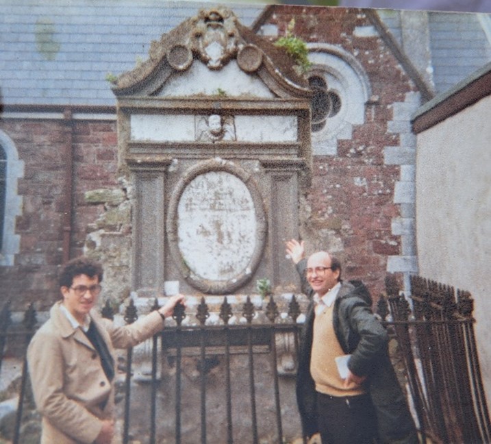
Gilles ( à droite) et Jean Noël Dargnies.
Ollie Sheehan commented that there are two archways on the outer walls of the tower, but the 1908 picture doesn't fit with either of them. There is another arch on the northern facing now inside in the extension that was erected about 70 years ago. Perhaps it was moved to facilitate this work.
Then, nearly eighty-four years after the JCHAS article another photograph was taken by Gilles Dargnies with his cousin, Jean Noël Dargnies, when they visited their ancestral home in 1982. His photograph appeared in a French magazine, Alliance Francaise, with an article he wrote currently being translated into English. Our Chairman, Jim Barry is liaising with Gilles on this project. Gilles, now retired, was at that time a high ranking French official based in Dublin, who purchased Belvelly castle for his son. The approximate location of the family vault has been highlighted by the blue oblong on the above map.
Christian graves tend to lie east/west. This is not the case with the Cotter Vault which runs north/south.
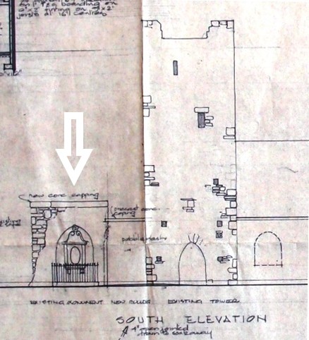
Enquiries were made to the Church of Ireland RCB Library by the society, seeking copies of drawings they had catalogued. The first of these most important drawings was of O’Flynn Architects dated, 15th May 1979, for the extension to abut the north face of the tower. From the south elevation it is clear the Cotter vault was in the middle of the carpark attached to the remnants of the Abbey wall on the north wall, with a construction note stating, ‘build up existing wall & make safe’, and in relation to the wall was to noted ‘new conc [concrete] capping’ to be formed.
Maps & Drawings
Sadly, other than the small marble plaque, today no trace of the Cotter family vault may be found, having been removed, it is believed during the 1980s redevelopment of the area, a period when construction planning procedures were very lax and practically non-existent to say the least. The following map is our best understanding we can offer for its movement’s location during the period 1908 through to 1980s; alongside of which is the architectural drawing of 1975 showing the same location.
|
|